
Scanstrut ROKK Mini Mount Kit for Tablets
How to use a tablet or phone as a chartplotter
Tablets and mobile phones can do most of the things that marine chartplotters can do. So can you forget about needing a chartplotter? Many people use a phone or tablet for navigation in all sorts of watercraft, from sailing yachts and motorboats to kayaks, RIBs, jet skis and even paddleboards. We'll be taking a look at the different setups but first, let's look at why you might want to use a tablet or phone, rather than a dedicated chartplotter.
It's prudent to point out that if you're going offshore or making long passages, a marine chartplotter (also known as a multi-function display, or MFD) hardwired into your navigation instruments is the best solution. They are designed and built specifically for that purpose, they are robust and reliable, and they will do everything that you need them to do. They're also expensive, though, and not everyone needs that level of integration, build quality or functionality.
A tablet or phone might not the ideal tool for navigation but it can do it affordably - and adequately, for many users. Before you decide that it's the best solution for you, there are some important considerations.
- Will it be used as a stand-alone device or integrated into an existing navigation system?
- Where will the device be located and mounted?
- How will you power it?
- How will you protect it?
- Do you need a dongle?
- What apps will you use?
A tablet can be used as a standalone device or integrated into your existing navigation system
Should your device be stand-alone or integrated?
This will depend on the type of vessel you're on (or in) and what other systems you already have in place. One of the clear benefits of handheld devices is that they can be used without any inputs. If you don't have instruments, for example in a kayak or dinghy, then you'll be using a handheld unit - either a smartphone, a tablet or a marine handheld GPS like the ones sold by Garmin - as a stand-alone device for navigation.
A tablet can be used for route planning and checking the weather, wherever you and your crew are.
[Credit] Excess Catamaran
Handheld devices are useful for route-planning, as you can do it at home and then take your device on the water. They're also worth having, even on a large yacht with its own dedicated navigation system, as back-up to get you home in an emergency when everything else has stopped working.
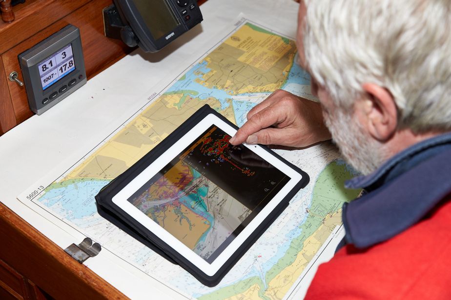
If you already have a log/speed/depth sounder and/or GPS fitted to your boat and it's all connected via a network (usually NMEA 0183 of NMEA 2000 - also called NMEA 2k) then you might already be able to connect your tablet or phone to the network via Wi-Fi. If not, for a few hundred pounds you can get a Wi-Fi server that is wired directly to the NMEA network and transmits the NMEA data, which can be received and displayed on your tablet or phone. This might include position, depth, course, speed over ground and speed through the water as well as AIS (automatic identification system) data.
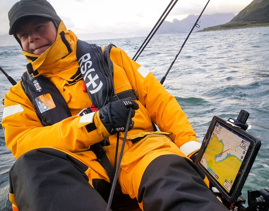
Working out the best place to install your tablet depends on how you intend to use it.
[Credit] Graham Snook Photography
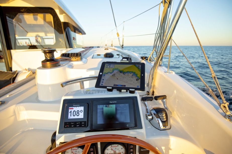
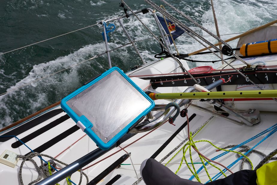
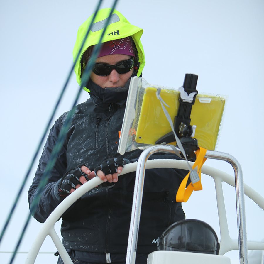
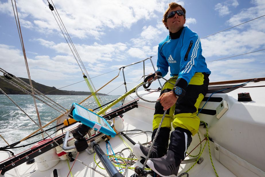
Where will the device be located and mounted?
Mounting a chartplotter is a relatively easy decision: either at the helm or at the chart table if you have one. A tablet or phone, on the other hand, can be mounted in any number of places depending on the activity and purpose you want it for. One of the benefits of the ROKK Mini mounting system is that you don't have to choose just one place, the system uses several different fixed mounting plates and the arm and tablet holder can be moved between them. The attachments don't even have to be permanent, there are suction mounts and zip-tie mounts in the range. Once you've tried a few locations and decided where's best, get one of the bases that can be securely screwed, bolted or bonded in place.
If you're going to be using a tablet for navigation on a larger vessel, it makes sense for it to be fitted within sight and reach of the helm. But doing this can expose the tablet's Achilles heel, especially on hot, sunny days. Anyone who has tried reading a phone through sunglasses on a bright day will know that visibility in sunlight isn't its strong point. Likewise, leaving a tablet or phone exposed to strong sunlight can cause the device to shut down to protect itself from overheating. At sea, if you're relying on the device to navigate and it suddenly goes blank you could be in a spot of bother.
You need to decide where the device will spend most of its time on board. While it's convenient to keep it switched on and showing your position, it may be better to keep it stowed or mounted in the shade until you need it, and then move it to a more exposed position where it's easier to refer to.
On a motorboat, you could mount a tablet on the flybridge (if you have one), then take it below to the inside helm. You could also fit a mount in the cockpit or saloon for watching films, streaming television or controlling your AV system.
Poor screen visibility in bright sunlight can be the downfall of tablet-based navigation.
[Credit] Graham Snook Photography
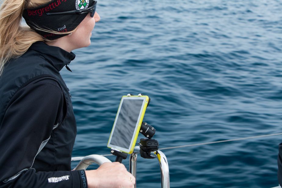
On a sailing yacht, a tablet could be fitted out of the way in the shade of the sprayhood, to a tube around the binnacle of a wheel or to a cockpit table between two wheels. Then in the evening you could spin it around 180 degrees for an after-dinner film. If your boat is small or you sail with fewer people it could be mounted to the pushpit or even the tiller so it's always within reach. If you're using the tablet to mirror or control a chartplotter, the tablet could be fitted at the chart table leaving the chartplotter on deck.
For fishers, it can be rail mounted while fishing as an extra fishfinder display and then moved to the helm when you head home. The Scanstrut ROKK Mini mount has a quick-release fitting, so it's easy to remove and use the tablet to grab a photo of your catch, then remount it securely.
If you're out in a RIB, rather than having a permanently attached chartplotter you could just add a tablet with a suction cup to the screen or console so you can take it off when you leave the boat.
Wherever you mount a tablet, we recommend attaching a tether in case it's pulled out of the mount, to stop it from taking a fall or floating away.
Scanstrut ROKK Mini Mount Kit for Tablets
How will you power the device?
How long will your device work on a single battery charge? That depends on the screen brightness and size, and how active the processor is. Some marine navigation apps will drain the battery surprisingly quickly if they're left on continuously. If you're going to use a tablet or phone for navigation, fitting a USB power source will save you from a ‘low power' warning when you need it least. This could be as simple as carrying a USB battery pack or the more permanent solution of fitting a USB sockets where the device is used. If that's impractical, consider fitting the USB socket where the device is stored when it's not in use.
If you want your tablet to be permanently powered, you should consider this when choosing a protective case for it as you'll need one that allows charging. Our range of chargers are designed to be fitted outside and are fully waterproof when not in use. The ROKK Charge+ and SC-USB-01 are also fully waterproof (to IPX6 and IPX4 respectively) with one or two cables inserted. If the location of your tablet is less vulnerable to water from rain and sea and you'll only be using it without a case, you can opt for the New for 2022 Flip Pro.
If you've chosen to use a smartphone on board, you can use USB charging sockets but if your phone allows wireless charging we have a better solution in the form of our waterproof wireless phone chargers. These are hardwired into your boat's 12/24V system and charge your phone wirelessly. The Active and Edge hold your phone securely, keeping it where you need it and charged. The Nest and Catch charge through the base while the phone is in contact with it, keeping the phone close to hand when you need it and charging it when you don't.
A waterproof case for your tablet is a must, especially if you're mounting it on deck.
[Credit] Graham Snook Photography
How will you protect it?
After considering where you're going to install your device and how it will be powered, you should then consider ways of protecting it. Whether you keep it on deck or give it a more comfortable life at the chart table, there is the ever-present concern of salt-laden air corroding its delicate circuitry. It's worth knowing that even waterproof devices tend to be be prone to corrosion.
What's the best type of case? That depends on your model of phone or tablet.
It's often a good idea to turn off the device's security features while you're on board, so you or your crew can use it immediately when it's needed in a hurry. This is important if you're sailing offshore - when you're off watch and asleep, your crew won't be waking you for your fingerprint to find out where they are. It's also worth checking how well the touch-screen works, with a case and without, when you're wearing gloves and when it's wet from rain or spray.
It is possible to do away with a mount, but that will make the device more vulnerable to damage. Like a television remote control it will have an uncanny knack of vanishing or dropping on the floor when someone gets up, especially with a cockpit full of people. Mounting the device avoids that issue and keeps it to hand when you need it.
If the device will just be used for emergency backup, it is worth buying a waterproof storage case and keeping some charged battery packs in the case. Then, if you lose all power and means of charging you have a separate independent system to navigate with.
Some tablets do not have GPS. If yours doesn't you'll need a GPS source
Do you need a dongle?
Many tablets have a GPS receiver built in but some don't. If yours doesn't, you'll either have to buy a small device called a GPS dongle, connect the tablet to another device that does have GPS, or buy a new tablet. There are two types of dongles: some plug directly into your device, others connect to it via Bluetooth. Both types have their drawbacks. Your device's battery will run out a lot sooner if you rely on Bluetooth, but you might struggle to find a good waterproof housing that fits the device with a plug-in dongle attached. Nearly all mobile phones have a GPS receiver built in, so you may want to consider using your phone instead.
If your tablet does have GPS, or if you're using a mobile phone to navigate, it might still be worth having a dongle. Many mobile phones and tablets have just a basic GPS receiver and use mobile cell triangulation to improve their accuracy from a potential margin of error of several hundred metres to just a couple of metres. This is called Assisted GPS (or A-GPS), and it uses a lot less battery power than a satellite-only Differential GPS (or DGPS) receiver with the same degree of accuracy. For many people Assisted GPS is adequate, but if you need very accurate position fixing in places where mobile phone reception is unreliable, then you probably do need a dongle.
Scanstrut ROKK Mini Mount Kit for Tablets
What apps will you use?
Hundreds of navigation apps are available and many of them are designed for boating. As a starting point, here are four that we've tested and know are reliable. The best one for you could depend on your location. Three of the most popular apps, with worldwide coverage, are C-Map, Navionics and iNavX. The fourth, from chart manufacturer Imray, is focused on Europe and the Caribbean.
If you already have a chartplotter on board, it's worth considering apps that allow you to connect to the plotter, and operate it, from your tablet or phone. B&G, Furuno, Garmin, Lowrance, Raymarine and Simrad all have apps that work with some of their latest chartplotters. You might, for example, have the plotter installed at the chart table inside the boat and want to use a handheld device in the cockpit.
Many apps are free, but you'll often pay a subscription for the charts you need. It's worth checking whether you'll lose access to the charts themselves, as well as the updates, at the end of the subscription period, or whether you'll still be able to use the charts without updates at the end of that period.
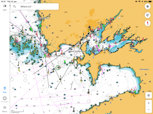
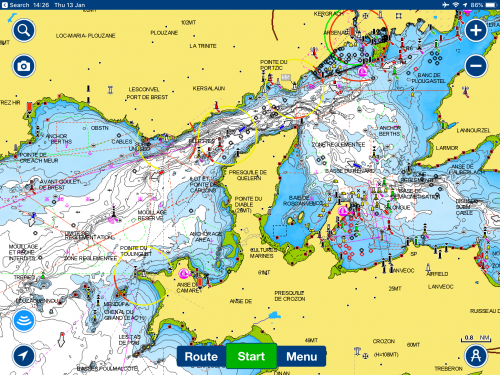
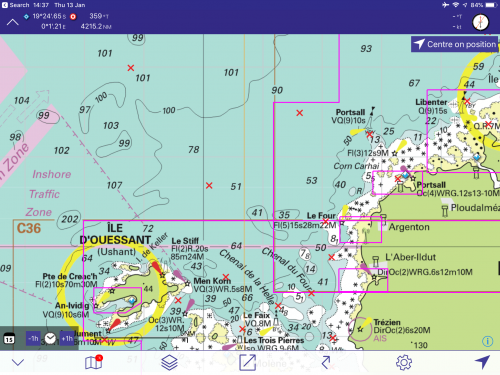
C-Map and Navionics use what are known as vector charts, where the information (such as depth soundings, buoyage and lights, tidal data and so on) is overlaid on a base map, and the user selects what is shown or hidden. The information is also arranged in layers, so the amount of detail depends on the zoom level. As you zoom out, some information is hidden to make the display easier to read. The snag with this is that you can end up hitting a rock that isn't shown on the screen because you're on the wrong zoom level. Vector charts have relatively small file sizes, so they are usually quite quick to download - when an update happens, you're just downloading the relevant section rather than a whole new chart folio.
The Imray app uses raster charts. These are like scans of printed charts, with all of the hydrographic detail displayed in one layer. The app will load the correct scale chart for the area you are zooming in on, and it can also overlay tidal data and weather data.
iNavX can display both raster and vector charts and you can use digital charts from your preferred manufacturer, be it Navionics, NV or NOAA - and NOAA charts are perhaps its greatest strength, as they are free to download and use.
C-Map
Clear maps, easy to use controls and navigation makes the C-Map app an attractive offer
Despite having a wealth of digital cartography, C-MAP was a bit of a late starter but its app is clean, easy to use, free to download and full of nice features like split-screen and weather. The downside is that you'll need a subscription to use it to navigate, to have charts offline, and to display an accurate position. At £43/year it's a cost-effective solution and good for route planning.
Navionics
Global coverage and simple to use interface set Navionics as the benchmark on app-based navigation
It was Navionics that transformed our phones and tablets into devices that could be used for navigation, and it's improved over the years. Like C-Map you have to subscribe to get detailed charts of your area. There is also the possibility to overlay AIS, display NMEA data and add to community layers with dive sites, fishing spots and so on. Its auto-routing works well.
Imray
Imray offers a familiar feel to those used to its charts, but only really offers European coverage.
Imray Navigator has lots of features that make it useful as a chartplotter. With waypoints that can be named and shared, Imray's partner apps add tides and AIS data. The raster charts sometimes show at different resolutions which can be off-putting. It's a more complex app than the others and does take a bit longer to master, but rewards those who do.
iNavX
Offering the largest option of international coverage from many cartography suppliers make iNavX a great option
Don't be put off by iNavx's large, simple-looking top display, it's this that makes it usable as a plotter. The tablet can be mounted and the screen read from a metre or two away. It uses raster and vector (including Navionics) charts and can overlay AIS (with further subscriptions). If you're in the US, you can navigate using all the NOAA charts for the $5 cost of the app.
